Expression of Interest Received
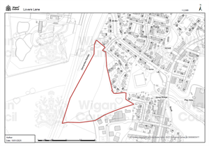
Site: Lovers Lane, Atherton – Wigan Council
Site Size: 3.1Ha/ 7.7Acres
Development Opportunity
Wigan Council is seeking interest from developers for a residential led scheme. The site has been identified as having the potential for residential development as per the Strategic Housing Land Availability Assessment.
Site Overview and Potential
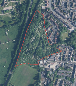
The site offers an excellent residential development opportunity in an already established residential area. The site is located within the Wigan and Bolton Growth Corridor, a key growth location which will see improved transport links including new road infrastructure. The site is predominantly green space with mature trees and shrubbery to the west and east of the site.
Location / Connectivity
 Less than 1 mile southwest of the Atherton town centre- one of the borough’s major local centres
- Close to schools and leisure facilities
- On the A579, Atherleigh Way, which links to both the A6 and M61
- Close to the A577 Wigan Road which links to both the A580 East Lancashire Road.
View red edge map of the Lovers Lane development opportunity.
Land ownership: Wigan Council