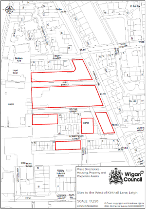
 Site: Sites to west of Kirkhall Lane - Wigan Council
Site Size: 0.92 hectare / 2.27 acres
Development Opportunity
Wigan Council is seeking interest from developers for a residential led scheme. The site has been identified as having the potential for residential development as per the Strategic Housing Land Availability Assessment.
Site Overview and Potential
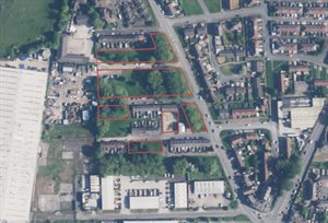
The site is split across 6 land parcels offering an excellent residential development opportunity in an already established residential area.
The land parcels along both Briggs Street and Robertshaw Street offer an opportunity to repair the missing frontages by providing a continuation of the existing terraced dwellings.
The parcels can all be characterised as maintained grass areas with areas of high density of mature trees and vegetation and therefore consideration will be needed to manage the ecological impact of development.
 Location / Connectivity
- Within 1 mile of Leigh Town Centre, which is currently subject to major regeneration activities
- Close to schools, leisure facilities and Leigh Hospital
- Just off the A579, Atherleigh Way, which links to both the A6 and M61
- A short distance from the Leigh Guided busway with direct links to Manchester City Centre
- Close to excellent outdoor amenities including Pennington Flash.
View red edge map of the Kirkhall Lane development opportunity.
Land ownership: Wigan Council