 Site: Hag Fold Cluster, Atherton - Wigan Council
Site Size: 1.78 ha/ 4.4 Acres
Development Opportunity
Wigan Council is seeking interest from developers for a residential led scheme. Due to the proximity of the sites, development would be expected to come forward as a cluster of estate housing.
Site Overview and Potential
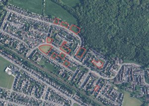
The Hag Fold cluster comprises of 11 sites offering an excellent residential development opportunity in an already established residential area. Most of the sites consist of medium to large, regularly proportioned green open spaces.
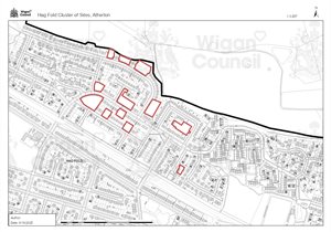
The Hag Fold cluster of sites presents multiple opportunities to deliver infill residential development on gap sites and repair missing frontages along the streets. The potential unit numbers across all 11 sites within this cluster sum to circa 73 dwellings, when considering the most appropriate dwelling type for this area.
Location / Connectivity
 Situated directly north of Hag Fold train station
- Less than half a mile north of the Atherton town centre- one of the borough’s major local centres
- Close to schools and leisure facilities
- Close to the A577 Tyldesley Road which links to both the A580 East Lancashire Road and to the A579 which links to both the A6 and M61.
View red edge map of Hag Fold cluster development opportunity.
Land ownership: Wigan Council